


The year 2019 marks the 30th anniversary of the opening of the inner German border Millions of people have since left the East for West Germany in hopes of a better life. ZEIT ONLINE has evaluated data on each of the approximately 6 million moves that took place from 1991, the first full year German unification, to 2017. With the help of relocation data from the residents’ registration offices, it is now possible for the first time to show where these flows went. The data tells one of the least documented stories of German post-war history, showing that after reunification, nearly a quarter of the original population of East Germany moved to the West, triggering a demographic crisis. Nearly every district lost people to the West between 1991 and 2017. More than a quarter of the population between the ages of 18 and 30 migrated to the West. Not only did states in eastern Germany lose tax revenues as a result, but in many places the ‘social infrastructure’ also collapsed. However, the data analysis shows a historical break for 2017: for the first time, more people are moving from West to East than the other way around. A decades-long trend of migration has come to a halt – for now.
To view the project online, click here.
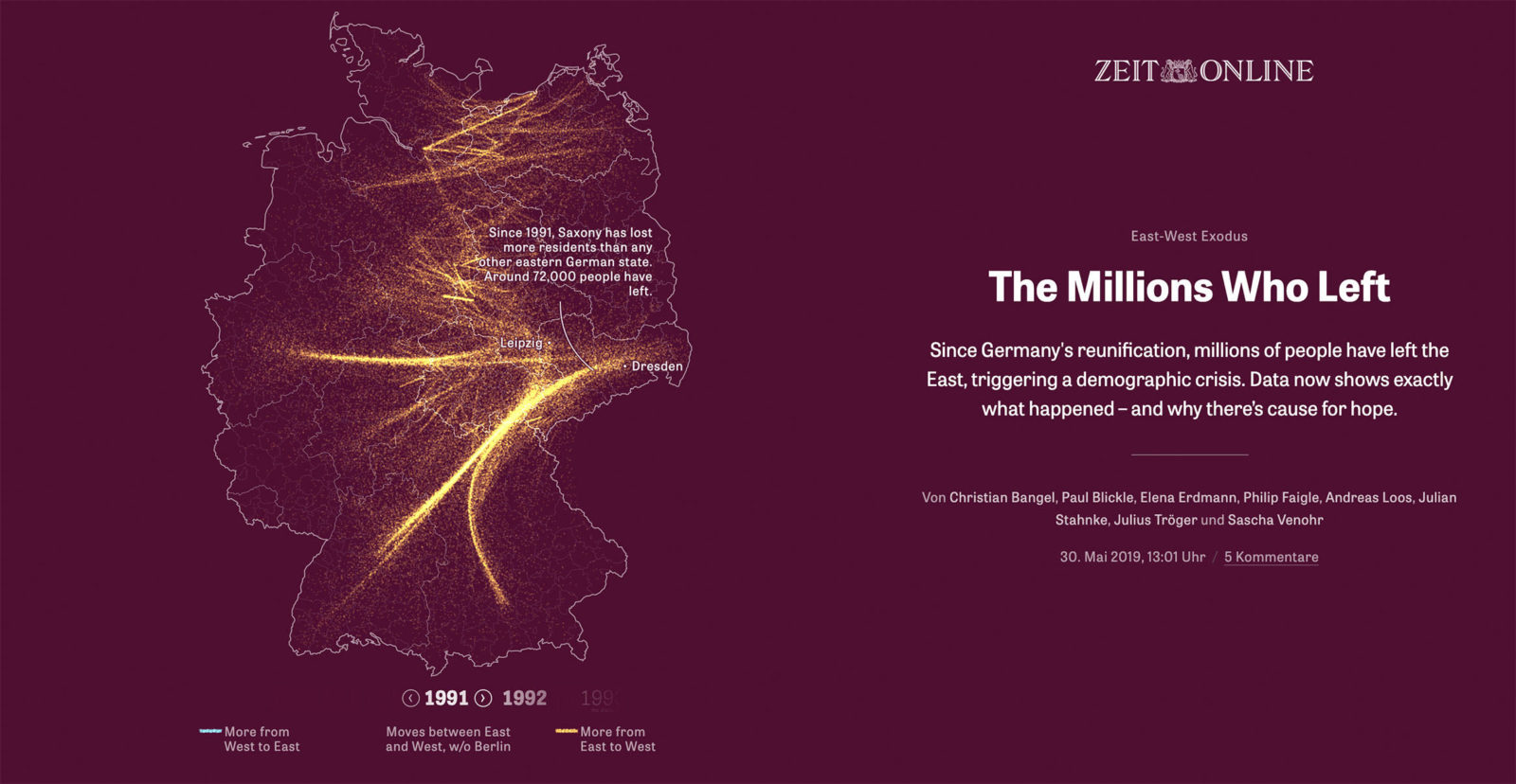
The map at the beginning of the article shows the 4,000 regions with the most net moves for all years counted. The migration flows were summarized by so-called ‘edge bundling’. Each dot that is visible corresponds to a single move. Some readers who had moved away from the East during this period reacted emotionally on Twitter and Facebook: ‘One of the small golden dots is me!’ The severity of emigration’s impact on the East is most apparent when one takes a closer look at the administrative districts and cities in the region. That is why readers can view the population development and relocation behaviour of their own region and are able to compare their very personal situation with others. They can view the demographic development for each county and city as if under a microscope.
The data were used to identify destinations for flanking reports. For example, the relocation data was used to find a municipality in East Germany where no West German has yet moved (articles written in German). The evaluations are based on data from Germany’s Federal Statistical Office, which encompass all moves between districts and cities in Germany between 1991 and 2017. The data in their raw form were not comparable because district borders have changed over time. As a workaround, we used the most recent demarcations from 2017 provided by the Federal Institute for Research on Building, Urban Affairs and Spatial Development (BBSR).
To view the project online, click here.